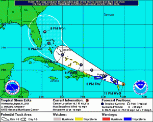
 Update, 11 p.m.: Tropical Storm Erika has shifted slightly east off its previous projected path.
The storm is now predicted to hit Florida from the east coast late Sunday into Monday as a hurricane, according to the National Hurricane Center 5-day Forecast Cone.
“No significant change in strength or perhaps some slight weakening is anticipated during the next 48 hours,” the NHC reported.
There is still a lot of uncertainty in the storm’s path. KnightNews.com will continue tracking Tropical Storm Erika.
Check back for update in the morning.
8 p.m.:
Is Florida ready for a hurricane after 10 years? Tropical Storm Erika seems to be heading toward the Sunshine State as it continues gaining strength.
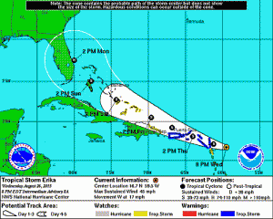
According to the 5-day Forecast Cone from the National Hurricane Center, Erika is predicted to enter Florida around Sunday night and reach Central Florida by Monday.
The Forecast Cone presumes that Erika will strengthen into a hurricane.

As of the latest NHC Intermediate Advisory, Erika is around 155 miles (250 kilometers) east of Antigua with winds at 45 mph (75 km/h).
“A west-northwestward motion at a slightly slower forward speed is expected over the next 48 hours,” The NHC advisory said.
However, Erika will have to face some obstacles before the storm makes it to Florida.
“Erika is forecast to move through an area of moderate to strong westerly shear during the next two to three days. Although the NHC intensity forecast during that time shows no change in intensity, weakening is possible during the next couple of days,” according to the NHC.
“Erika also has the potential to temporarily stall or move very slowly somewhere near the Florida peninsula next week. Depending on the exact path, this has the potential to bring excessive rainfall and flooding to parts of the Sunshine State,” the National Weather Service reported.
Erika is expected to make its way through the Leeward Islands overnight.
KnightNews.com will continue to track Tropical Storm Erika. Check back for updates.


