UPDATE: Tropical Depression Three grew into Tropical Storm Collin, according to the National Hurricane Center.
UPDATE: NHC has upgraded #TD3 to #TropicalStorm #Colin. Recon data supports higher sustained winds… #WESHwx pic.twitter.com/NgKInaR2iy
— Kyle Gravlin (@kylegravlin) June 5, 2016
As of 5:40 p.m., winds are peaking at 40 mph.
The NHC said Tropical Storm Colin is the earliest third tropical storm to form on record in the Atlantic basin.
Check back on Knight News for coverage on Tropical Storm Colin.
Florida seems to be wasting no time when it comes to the start of hurricane season.
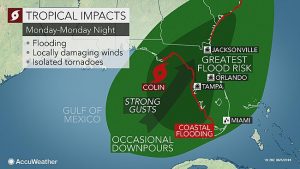
Tropical Depression Three formed in the Gulf of Mexico on Sunday and the National Hurricane Center predicts it will hit Florida as Tropical Storm Colin Monday afternoon.
This means heavy rainfall and slight flooding for the University of Central Florida area even though the direct path is Northwest Florida, according to AccuWeather.
“Even if this system does not develop into a named storm, it still poses significant risks from flooding, damaging winds and tornadoes, and rip currents. This is expected to be a fast-moving storm, which means that it could mature very rapidly and very close, giving us little warning,” Florida Division of Emergency Management Director Bryan Koon said in a release.
TD 3 should produce heavy rain & possible flooding in Florida during the next few days. More:https://t.co/tW4KeFW0gB pic.twitter.com/imAO9TUklH
— NHC Atlantic Ops (@NHC_Atlantic) June 5, 2016
Local meteorologists are also tracking the direct impact to Central Florida.
Wind and #surge for #TampaBay #FortMyers #Sarasota late Monday. Gusty for cent FL too! #EyeonTropics #wftv pic.twitter.com/Miu4k03FYa
— tom terry (@TTerryWFTV) June 4, 2016
“Regardless of the strength of the depression, torrential rain will push across Florida and southern Georgia from Monday into Monday night,” AccuWeather reported.
As of 4 p.m. Sunday, Tropical Depression Three is moving north at 12 mph with winds peaking at 35 mph, according to AccuWeather.
Knight News asked reached out to UCF to see if any precautions are being taken but did not receive an immediate response.
Check back on Knight News for severe weather updates.
Image credit: AccuWeather, NOLA, NHC


