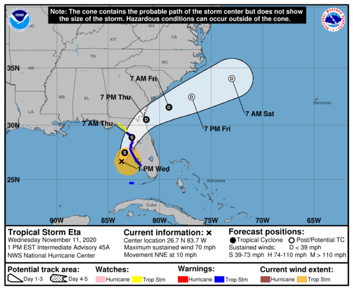
Tropical Storm Eta is on a fluctuating path toward Florida and is likely to bring heavy rains and gusty winds across the west-central parts of the Sunshine State.
The National Hurricane Center reported in a 1 p.m. update that the area including west and central Florida is expected to see 2 in to 4 in of rain through Friday, with a maximum of 6 inches of rain.
The NHC reports Tropical Storm Eta’s maximum sustained winds have decreased to 70 mph as it continues to move east and prepares to make landfall around the Big Bend area in Florida Thursday morning, according to the 1 p.m. update.
A hurricane watch is in effect for Anna Maria Island to Yankeetown, Florida, while a tropical storm warning is in effect for Dry Tortugas, and Bonita Beach to Suwannee River, Florida.
A storm surge warning is in effect for Bonita Beach to Suwanee River, including Tampa Bay and Charlotte Harbor, Florida.
A storm surge watch is in effect for Steinhatchee River to Suwannee River, Florida, while a tropical storm watch is in effect for the area north of the Suwannee River to Aucilla River, Florida.
The tropical storm is forecasted to make landfall around Homosassa Springs, Florida, Thursday morning.
Forecasters reported in the 1 p.m. update that models have shifted the storm’s impact slightly more east, and have not ruled out the possibility of a landfall anywhere near Tampa, Florida.
“Slow weakening is expected as Eta approaches the west coast of Florida tonight, followed by rapid weakening after landfall occurs on Thursday,” the 1 p.m. update reads.
As Tropical Storm Eta continues to creep towards Florida, both its path and intensity are still unknown and have changed drastically within the last 48 hours.
After making landfall in Nicaragua as a Category 4 hurricane on Tuesday, it weakened to a tropical depression before reentering the waters of the Caribbean Sea. During the 10 a.m. update Wednesday morning, just hours before publication, the tropical storm was classified as Hurricane Eta.
This is a developing story.
Check back with Knight News for updates.


