UPDATE JULY 11 11:00 A.M. Tropical Storm Chantal has weakened into a tropical wave but still has maximum sustained winds of 45 mph. Forecasters expect the storm to continue to weaken.
UPDATE 11:00 A.M. TS Chantal is weakening and may turn into a Tropical Wave. Maximum sustained winds are at 45 mph and the storm’s projection cone has moved considerably West, placing Florida in the center of it’s path.
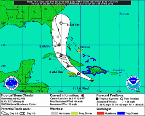
The latest National Weather Service forecasts show Tropical Storm Chantal’s path shifted more towards the west and towards Florida.
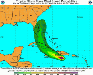
TS Chantal has strenghtened, now producing maximum sustained winds at 65 mph as it moves West-North-West at 29 mph away from the Lesser Antilles and into the Eastern Caribbean Sea.
The storm’s current path projects the storm to reach east of Miami by Friday with winds around 50 mph. The entire eastern coast of Florida is inside the cone.
Watch a video preparedness guide in case a storm hits Central Florida.
A hurricane watch it currently in effect for Barahona to Samana Dominican Republic.
A topical storm warning is in effect for
– Puerto Rico
– entire Coast of the Dominican Republic
– Guadeloupe
– Martinique
– Dominicia
– North Coast of Haiti
A tropical storm watch is in effect for:
– U.S. Virgin Islands
– Vieques and Culebra
– Turks and Caicos
– Southeaster Bahamas
Continue to check back for continuing updates and projections for the storm. Follow @UCFKnightNews for more.


