
Hurricane Ian made landfall in Florida this afternoon as a near category 5 Hurricane flooding cities along the gulf coast as the eye makes its way to Central Florida later Wednesday night.
The National Hurricane Center reported the storm made landfall over Cayo Costa State Park at 3:05 pm as a Category 4 Hurricane with sustained winds of 155 mph. Hurricane Charley made landfall in nearly an identical spot with 150 mph wind speeds when it hit the Florida Peninsula on Aug. 13, 2004.
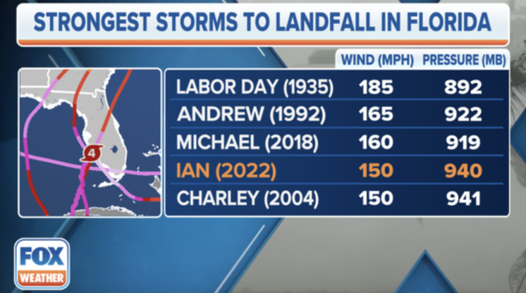
According to FoxWeather.com, Ian is the fourth strongest hurricane to hit Florida in recorded history with only the Labor Day Hurricane of 1935 (185 mph) Andrew of 1992 (165 mph) and Michael of 2018 (160 mph) having stronger wind speeds.
According to the UCF Department of Emergency Management, hurricane warnings are in effect for Polk, Lake, Orange, Osceola, Seminole, Brevard and Volusia counties with a Flood Watch in effect for all east Central Florida counties. A Tornado watch is all in effect for Brevard, Orange, Osceola and Seminole counties until 1 a.m. Thursday Morning.
The NHC released the following statement on the eye of the storm hitting Central Florida at around 11 p.m. tonight:
“The center of Ian is forecast to move over central Florida tonight and Thursday morning and emerge over the western Atlantic by late Thursday,” The Hurricane Center said in a statement.
Currently storm surge of over 6 feet has hit parts of Fort Myers with extreme flooding
Gov. Ron DeSantis said that the storm will have major impacts of the state similar to when Charley hit the peninsula in 2004.
“At a minimum, it’s going to be a very strong Category 4 that’s going to rank as one of the top five hurricanes to ever hit the Florida peninsula,” DeSantis said. “You can compare Charley to this. This is way, way, way bigger than Charley. This was as strong as Charley coming in, but Charlie was much smaller. So this is a big one. I think we all know there’s going to be major, major impacts.”
Flooding is expected throughout the Central Florida are with spots as high as 24 inches.
UCF Alert is advising Students to stay inside for the duration of the storm into tomorrow.


